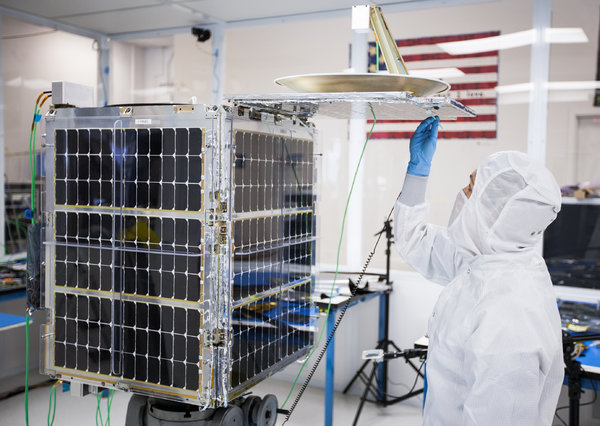
 PEOPLE already worried about the candid cameras on Google Glass and low-flying drones can add a new potential snooper to the list: cameras on inexpensive, low-orbiting microsatellites that will soon be sending back frequent, low-cost snapshots of most of Earth’s populated regions from space.
They won’t be the first cameras out there, of course. Earth-imaging satellites the size of vans have long circled the globe, but those cost millions of dollars each to build and launch, in part because of their weight and specialized hardware. The new satellites, with some of the same off-the-shelf miniaturized technology that has made smartphones and laptops so powerful, will be far less expensive.
The view from high up is rich in untapped data, said Paul Saffo, a forecaster and essayist. He expects the new satellite services to find many customers.
Insurance companies, for example, could use the satellites’ “before” and “after” views to monitor insured property and validate claims after a disaster. Businesses that update online maps for geologists, city planners or disaster relief officials could be customers, too. The images could also be used to monitor problems like deforestation, melting icecaps and overfishing.
And food companies and commodities traders could use the images to keep track of crops and agricultural yields all over the planet, Mr. Saffo predicted.
But the images are also likely to be viewed as the latest mixed blessing by people already apprehensive of Big Brother-like surveillance in their lives.
First into space in the microsatellite business will be the San Francisco company Planet Labs, which plans to launch a fleet of 28 small satellites at the end of the year that will photograph the planet around the clock, with frequent updates. The company has already sent up two trial satellites for test runs, and will dispatch the entire set, called Flock-1, in December, said Will Marshall, a co-founder of the company and a former NASA scientist.
The Planet Labs’ satellites won’t be able to distinguish your face or read your license plate — the cameras don’t have that level of resolution. But the frequency with which images can be updated could raise privacy questions, said Timothy Edgar, a visiting fellow at the Watson Institute for International Studies at Brown University and a former director of privacy and civil liberties in the Obama administration.
Mr. Edgar contrasted the satellite images with those provided by Google Earth — the ones that people zoom in on to see, for example, an aerial view of their homes.”That’s just an image of your house that was probably taken a few years ago,” he said. “It may feel like you are being watched, but you aren’t. It’s just a static picture that’s most likely several years old.”
But a satellite that regularly passes over your cabin deep in the woods and photographs a car that is sometimes parked there — and sometimes not — has different ramifications. “It can show a pattern, for example, when you appear to be at home and when you’re away,” he said.
Planet Labs’ technology, like that at other microsatellite companies such as Skybox Imaging, are benefiting from the progressive miniaturization of consumer electronic components, along with a federal effort to commercialize space. “What we are seeing are smaller satellites that have similar capabilities to much larger, traditional satellites,” said Glenn Lightsey, a professor at the University of Texas who founded and directs the Texas Spacecraft Lab there. “Since putting a satellite in orbit is a function of its size, these new satellites are able to get into orbit at a much lower cost,” he said.
The lightweight satellites have another advantage: the companies don’t have to spend millions of dollars for a rocket to get them into space. Instead, they can hitch a ride as a secondary payload on a rocket already making the trip. Planet Labs will send its satellites on an Antares rocket when it heads out on a cargo transportation flight to the International Space Station.
Investors have flocked to the new satellite companies, though neither Planet Labs nor Skybox Imaging has disclosed what it will charge customers. Planet Labs has obtained $13.1 million in funding, led by Steve Jurvetson, managing director of Draper Fisher Jurvetson. Other backers include O’Reilly AlphaTech Ventures, Data Collective and First Round Capital.
Five ground stations will receive the Planet Labs imagery as the satellites pass overhead. Dr. Marshall would not disclose how often the satellites would pass the same spot. “The point is that by putting up lots of satellites, we can image the whole Earth on a much more frequent basis,” he said.
Skybox Imaging, in Mountain View, Calif., aims to provide sharply detailed images as well as high-definition video with its satellites. The company, which has raised about $91 million, expects to put its SkySat-1 and SkySat-2 satellites into orbit later this year, said Dan Berkenstock, a co-founder, and then follow with a group totaling 24 satellites. Customers will be able to buy images or an appliance to download information directly from the satellite. “They can log onto our satellite and ask it to take pictures,” he said.
Japan Space Imaging, a subsidiary of the Mitsubishi Corporation, recently signed a contract with Skybox allowing it to directly downlink imagery for agricultural and maritime monitoring as well as for disaster response.
Microsatellite services promise a new, accessible way to monitor global changes such as crop growth, said Anthony Janetos, director of Boston University’sPardee Center for the Study of the Longer-Range Future. “You can’t understand these forces if you can’t measure them,” he said. “These services will be useful in gathering those measurements.”
The new satellites are yet another stage in the expansion of the human view aided by powerful cameras and digital communication, said Mitchell Stephens, a journalism professor at New York University and author of “The Rise of the Image, the Fall of the Word.”
This change has pluses and minuses, he observed. People who try to build a private hideaway in the woods might come to realize that it isn’t so private. But such images could also spot illegal logging in remote spots.
“Now we can have a Godlike view, looking down from the heavens,” he said. “I can understand why people would be nervous. But the cameras can make the world more transparent and open. I’m for that.”
By ANNE EISENBERG
New York Times
E-mail: novelties@nytimes.com.


